

EB-2025-0797 | August 2026
New Technologies for Oyster Farming: An Overview of Smart, Sustainable Shellfish Aquaculture Management (S3AM)
Introduction
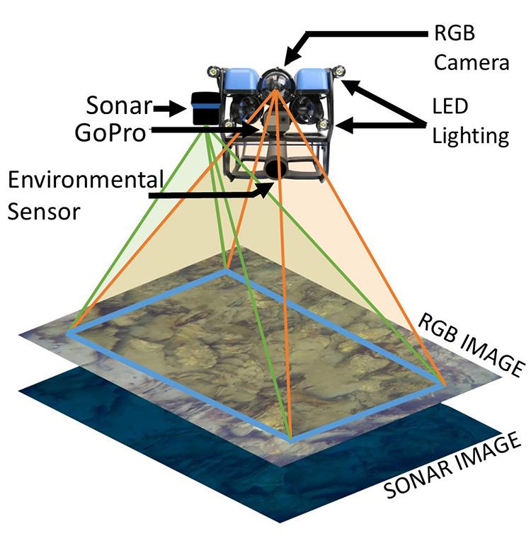
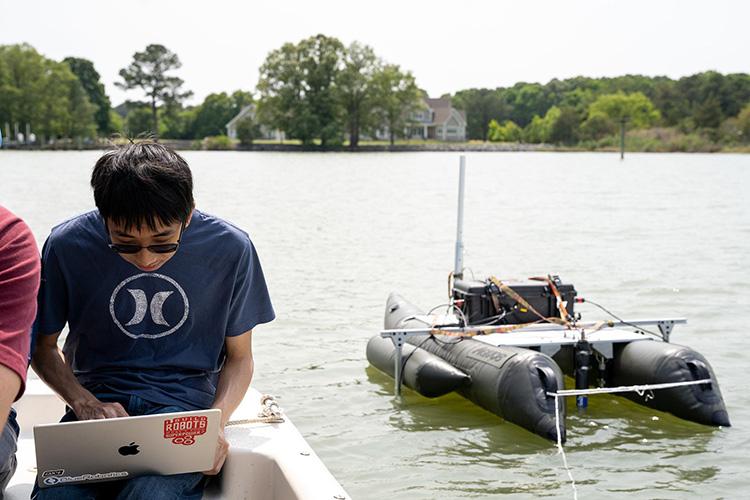
Smart Sustainable Shellfish Aquaculture Management (S3AM) is an aquatic monitoring technology designed to revolutionize oyster farming by bringing precision, efficiency, and sustainability to the production of “on-bottom” oysters grown on the sea floor. Developed through a collaboration between academic institutions, nonprofits, and commercial partners, S3AM uses underwater drones and surface vehicles to map oyster beds. Cameras and sensors monitor crop health and inventory in real time, and make it possible to assess conditions underwater. The system helps oyster farmers harvest more efficiently by using GPS and environmental data to plan the best routes, saving time, fuel, and effort while boosting the number of market-sized oysters collected. By giving farmers quick and accurate insights to make smarter decisions, S3AM leads to better profits for the aquaculture industry and healthier waterways for the Chesapeake Bay. This publication summarizes the history and current state of oyster aquaculture while highlighting the need for technologies that improve production efficiency. It is intended for on-bottom oyster aquaculture producers, watermen, restoration groups, public agencies, and others interested in Chesapeake Bay sustainability.
Background
History of Oyster Aquaculture in Maryland
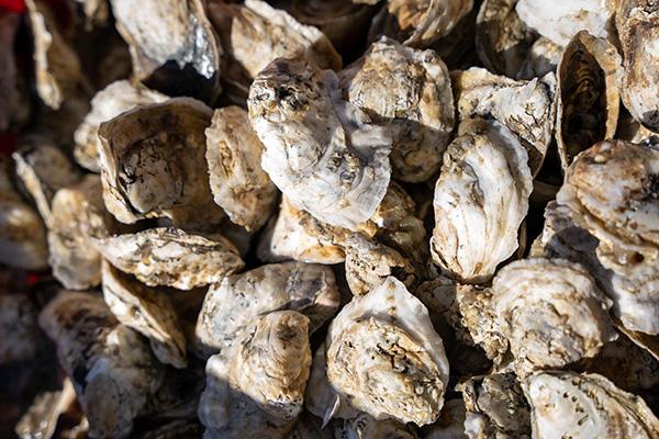
The Eastern Oyster (Crassostrea virginica) is a bivalve mollusk with a broad habitat range across the east and Gulf coasts of the Americas. These filter feeding animals can process up to 50 gallons of water per animal daily, creating habitat and providing food for many species of plants and animals. Oysters are critical to cleaning up waterways and have traditionally been an economic boon to coastal economies. For thousands of years, native populations consumed oysters, which, in Chesapeake Bay, were once so abundant that they created three-dimensional reefs that protruded out of the water, even causing ships to run aground. This plentiful, nutritious, easily accessible, and reliable protein source became a cultural staple of the region, allowing populations to thrive.
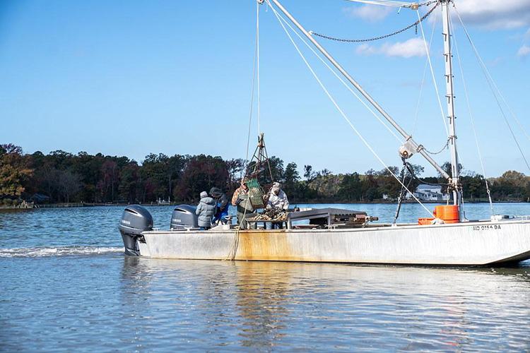
Native people traditionally harvested oysters by hand or using hand tongs, and they taught European settlers their collection methods; for centuries, these tongs were a main harvesting tool in shallow depths of up to 20 feet. In the nineteenth and twentieth century, new harvesting tools/methods were developed, leading to practices still in use today. Towed oyster dredges, developed in the 1800s, were initially used on sailing vessels; now these dredges are towed by motorized craft. In the 1900s, tools like the hydraulic patent tong allowed harvesters to reach oysters in deeper parts of the Bay. Later in the century, commercial diving was approved for harvesting in certain areas, enabling divers to collect oysters from the steep edges of oyster beds—places that were too hard to reach with traditional hand tools.
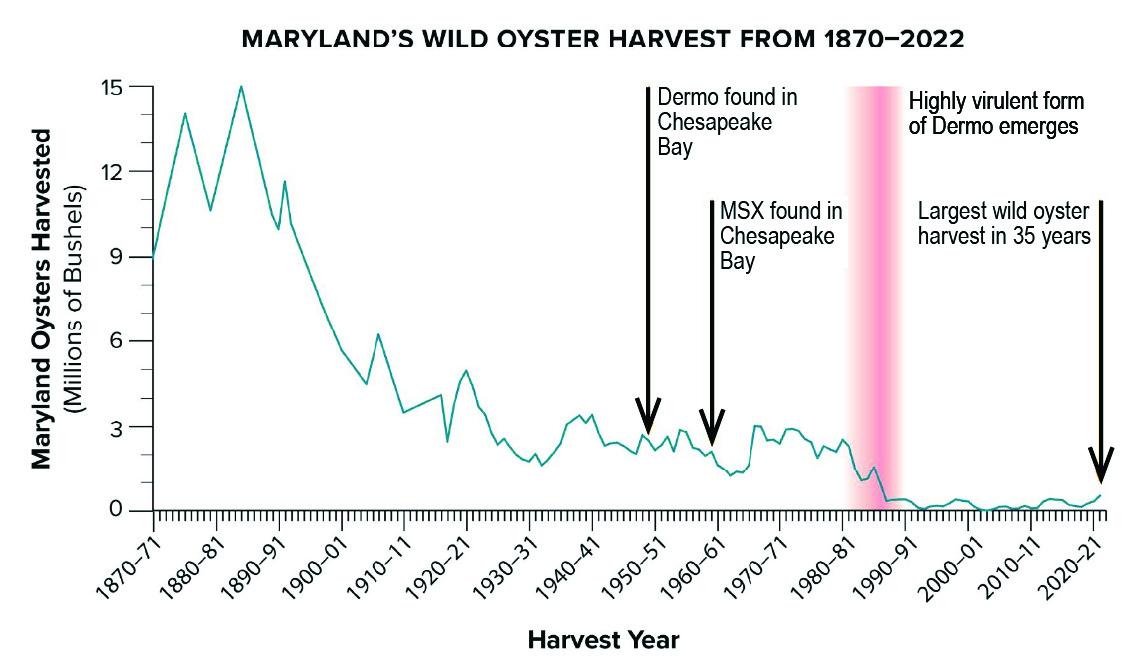
When people started shucking oysters to remove the meat, using canning to preserve it, and shipping it across the country by railroad, oysters became a cheap and widely available food. This growing demand led to larger harvests throughout the 1800s and 1900s. Despite record harvests of 15 million bushels in 1885, scientists were already observing signs of overharvest and warning that oysters were being removed faster than the population could replenish, raising concerns about an eventual collapse (Brooks, 1996). After that, the yearly harvest dropped sharply, averaging only 2.5 to 3 million bushels from 1930 through the mid-1980s. The ongoing demand and limited oyster supply led to the need for cultivation practices to supply the market.
Although many production methods are used worldwide, most farmed oysters in Maryland are grown on-bottom, or on the seafloor, in a way that mimics natural reefs. Farmers spread shell across the bottom and plant young oysters (spat) onto it to prevent them from sinking into the mud. These oysters are typically harvested in bulk for processing, such as shucking and packaging. This publication focuses on on-bottom culture and does not cover water-column methods, which use suspended cages to produce higher-value but more labor-intensive oysters.
Oyster Biology
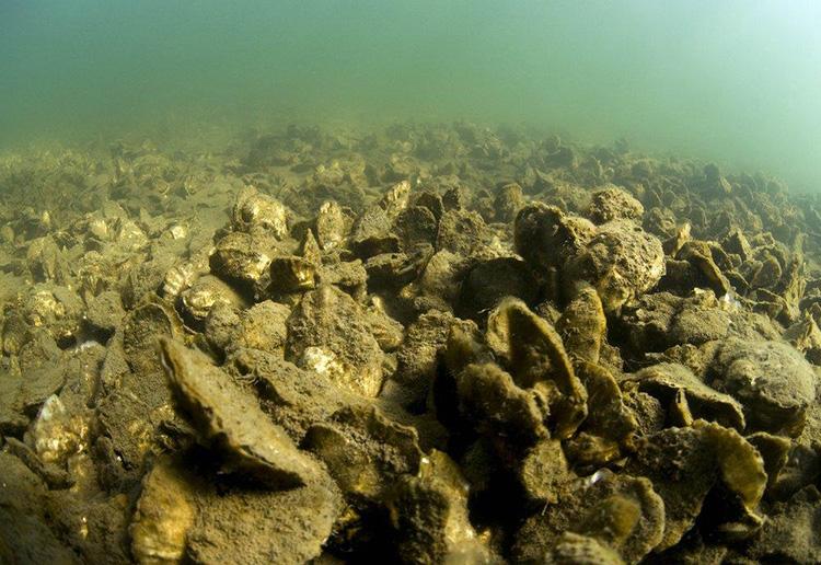
Oysters thrive in environments with brackish to saline water, abundant phytoplankton (algae) for feeding, sufficient dissolved oxygen, and hard substrates for larvae to attach and grow. Ideal growing conditions also include steady water flow to deliver food and prevent sediment buildup, along with good water quality to support survival and reproduction (Flimlin et al., 2010). Historically, the Chesapeake Bay has offered many of these optimal conditions, making it one of the most productive oyster habitats in the United States. Its mix of freshwater and saltwater creates a brackish environment well-suited for oyster growth, and its natural abundance of hard-bottom areas once provided ample surfaces for larvae to settle. The bay’s tidal currents helped circulate nutrients and maintain oxygen levels, supporting robust oyster populations.
However, modern oyster farming in Chesapeake Bay faces significant challenges. Water quality has declined due to contamination from urban runoff, industrial activity, and agricultural effluent, introducing pathogens and excess nutrients. These nutrients fuel algal blooms that lead to hypoxia— low oxygen conditions detrimental to oyster health. Periodic freshets, or large influxes of freshwater, further disrupt salinity levels, especially in the upper bay, making conditions less favorable for oysters. Oyster populations are also vulnerable to a range of diseases, such as Dermo (Perkinsus marinus) and MSX (Haplosporidium nelsoni), which can significantly reduce survival rates and hinder reproduction. Additionally, the loss of hard substrate from historical shell harvesting, siltation, and disease pressure has reduced suitable areas for larvae settlement. Selecting optimal farm sites now requires careful consideration of these biological and environmental factors to ensure shellfish survival and growth.
Oyster Regulations
Maryland was one of the first states to support oyster farming. In 1830, the “One Acre Law” allowed individuals to lease small plots for oyster culture; by 1865, this expanded to five acres. As oyster harvests declined in the late 1800s, scientists advocated for expanding aquaculture to reduce pressure on wild stocks, sustain the fishery, and maintain national markets. In 1906, the “Haman Law” marked a major step forward by requiring the state to map and permanently protect natural oyster bars for public use. Over time, however, restrictive leasing laws and local opposition limited the growth of aquaculture, and many counties curtailed new leases. Wicomico County on Maryland’s lower Eastern Shore was a notable exception, holding over a quarter of the state’s leases and supporting one of the nation’s largest oyster companies into the mid- 1980s.
Efforts to revitalize the industry culminated in a major policy shift following the 2008 Maryland Oyster Advisory Commission report, which led to sweeping legislative reforms enacted in 2009. These changes overhauled the state’s leasing system, available for aquaculture, and made it easier for individuals to obtain leases, ultimately enabling rapid growth of Maryland’s modern oyster aquaculture industry (UMD Extension, 2021).
Aquaculture Lease Site Selection
In the state of Maryland, to farm oysters commercially, you must obtain a lease from the Maryland Department of Natural Resources (DNR) (Maryland OneStop, 2025). This lease grants the right to plant, grow, and harvest shellfish on a designated area of submerged land (on-bottom) or water column (cages). One purpose of S3AM is to assist lease applicants in finding ideal locations for new leases by providing critical information about the bottom substrate and water quality.
While biological and physical factors are essential when considering lease site selection, social and regulatory considerations also play important roles. There are many competing stakeholders who use coastal waters that regulators consider in the permitting process: besides commercial harvesters, they account for recreational boaters, waterfront property owners, the shipping industry, and the military. Nationally, oyster lease siting regulations vary by state, with some allowing farmers to choose their own sites (if they meet requirements), while others designate specific aquaculture zones. The level of state analysis on site suitability also varies. As a general rule, farmers must avoid areas with submerged aquatic vegetation and navigational channels, as these are typically restricted.
Maryland’s Natural Resources Article 4-11A outlines the legal framework for oyster aquaculture leasing. Specific sections govern different lease types:
- 4-11A-06 - submerged land leases outside the Coastal Bays.
- 4-11A-07 - submerged land leases within the Coastal Bays.
- 4-11A-08 - water column leases.
COMAR 08.02.23.03(E) outlines additional location-based restrictions, and regulators require habitat assessments for lease applications in Public Shellfish Fishery Areas (PSFAs) or oyster sanctuaries. A PSFA cannot be declassified for leasing if it contains an average of more than one oyster over one inch per square meter, as determined by a state survey (COMAR 08.02.04.17). While no specific metric exists for leasing within sanctuaries (except in the St. Mary’s River), the Department must ensure proposed aquaculture activities are compatible with restoration goals. This involves reviewing past and planned restoration efforts and conducting habitat surveys to assess potential impacts, favoring lease placement on relatively barren bottom areas. In Maryland, on-bottom shellfish farmers must have a state lease approved by the Maryland Department of Natural Resources and a federal permit from the US Army Corps of Engineers Baltimore District (Maryland OneStop, 2025).
Inventory management
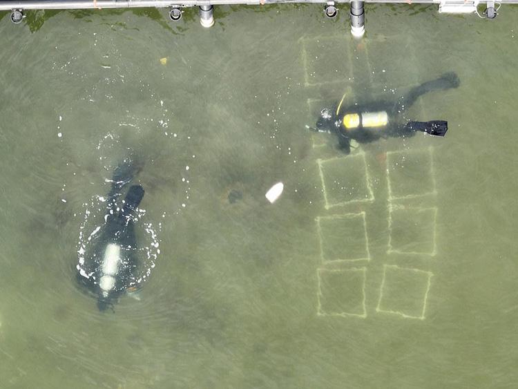
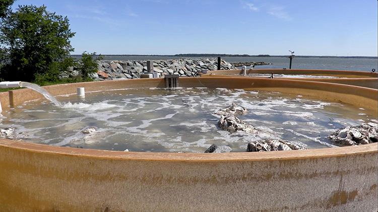
On-bottom oyster farms are typically seeded by washing spat-on-shell oysters produced in onshore tanks (e.g. remote setting) off the deck of vessels while they transit the lease. As a result, oyster farmers have traditionally operated under conditions of great uncertainty when managing inventory, since they lack information and reliable methods for assessing their crop. They have no way of knowing precisely where seeds land or how they have grown, and cannot determine survival rates. Growers must operate without crucial information about their inventory, including the location of areas with increased predation or mortality rates, and, ultimately, how much product they will have to market. Today, when finding and monitoring their oyster inventory on a lease site, oyster farmers continue to rely on traditional methods involving manual sampling and visual inspection. They take samples with a sounding pole to indicate bottom hardness, conduct SCUBA diving surveys, catch some product using hand or patent tongs, and tow dredges and scrapes. While useful to get a general idea of oysters’ location and growth, these techniques lack precision and a wide area of coverage. Traditional methods are labor-intensive, limited in scope, and often fail to provide reliable estimates. They can also miss key environmental changes and crop health issues.
Harvesting Technology
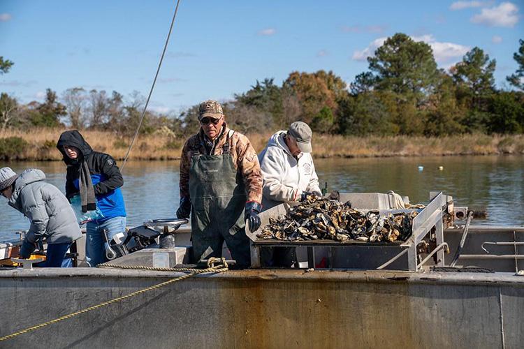
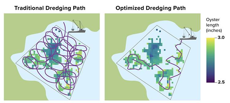
While several methods of oyster harvest exist for on-bottom oysters (e.g. tongs, diving, etc.), the dredge is the most popular. An oyster dredge requires harvesters to use a workboat with a mast and boom (e.g. davit) and tow the unit from the starboard side. A hydraulic winch located on the boom allows them to lower and raise the unit. Once harvesters lower the boom, they fasten a second line attached to the front of the dredge to a cleat on the starboard quarter. To avoid the line wearing on the vessel hull, the dredge is towed with any turns made to starboard. The side-mounted dredge position causes vessels to move in a circular pattern, drifting randomly across the lease. When harvesters feel the dredge is full, they use the winch to pull it to the vessel and from the water, where it is swung over a sorting table for separating marketable oysters from shell and bycatch. The crew continues the dredging and sorting process until they have reached their catch quota or, in order to comply with shellfish sanitation laws (NSSP, 2023), return to the dock within legal harvest hours.
Introduction to Smart Sustainable Shellfish Aquaculture Management
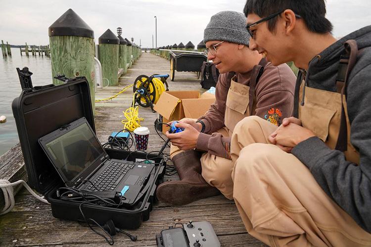
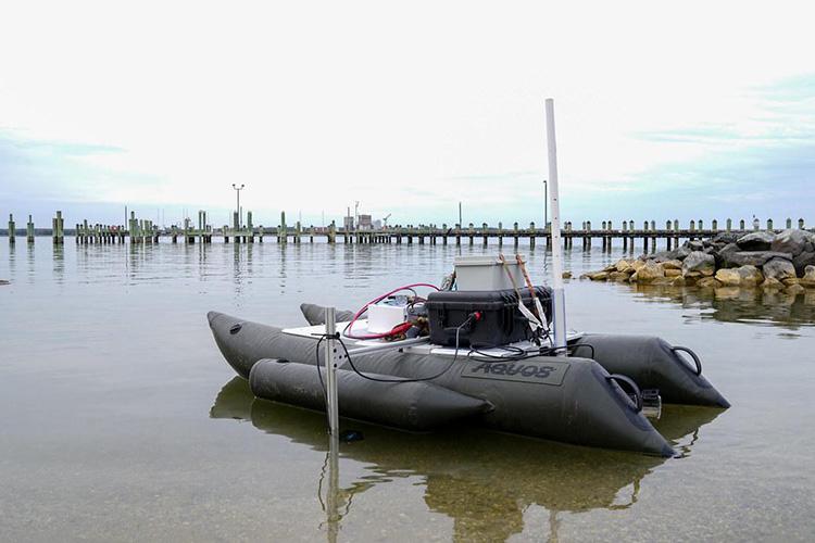
Smart Sustainable Shellfish Aquaculture Management (S3AM) is a technology developed by engineers, computer scientists, and aquaculture researchers at the University of Maryland, College Park, to support on-bottom oyster farmers, nonprofit restoration groups, commercial watermen, and natural resource agencies managing wild oyster populations. S3AM combines underwater and surface robots and mapping tools, enabling stakeholders to collect detailed data on oyster beds, including their location, size, and the condition of the oysters growing in them. The software is designed to be openly available to stakeholders and provided in compatible formats that make it accessible to a wide range of users. Oyster farmers and watermen can use S3AM technology to plan harvests more efficiently by targeting areas with the highest number of market-sized oysters. This kind of precision harvesting reduces wear on their equipment, saves time, fuel, and labor, and allows them to make the most of the short harvest windows regulated by law. S3AM also supports better inventory tracking by making it possible for farmers to monitor survival rates and growth over time, and use the information to decide whether to harvest, wait, or re-seed areas where oysters are not thriving. Enhanced tracking can prevent years of lost production and improve overall farm performance. Ultimately, oyster growers can make smarter decisions, reduce waste, and improve both the sustainability and profitability of their operations by using S3AM.
Substrate Sensing
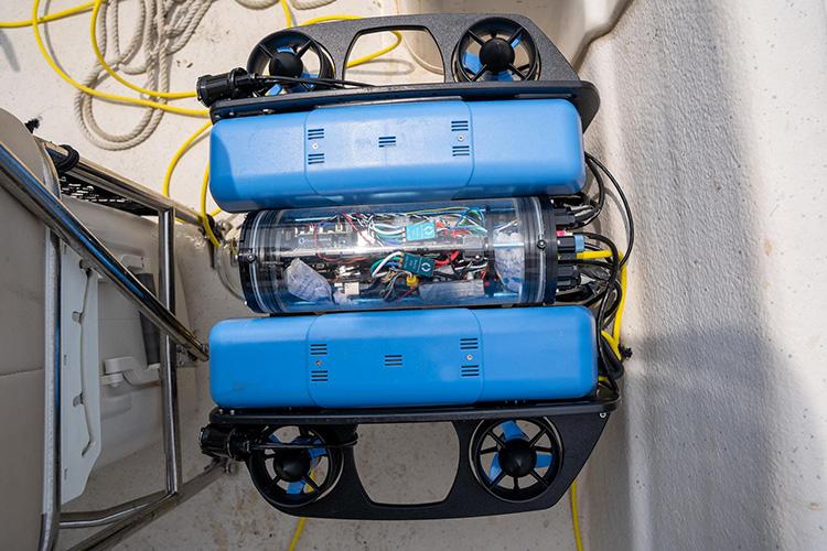
To assess and manage seafloor environments where oysters grow, S3AM uses aquatic drones equipped with sonar and imaging technology to scan the bottom of subtidal leases. Since substrate influences oyster attachment, growth and survival, understanding its composition is essential for successful oyster cultivation. S3AM’s scans produce high-resolution maps of substrate types, including sand, mud, gravel, and shell hash or clutch, which is composed of degraded oyster shell fragments.
Oyster Monitoring and Inventory Mapping
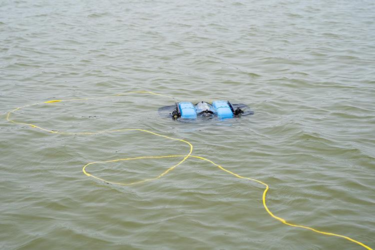
S3AM enhances monitoring by providing precise, real-time insights into the condition and distribution of oysters in subtidal beds. Using sonar and imaging technology, the same drones providing information about substrate composition also collect detailed data on oyster location, density, and distribution. When processed into geospatial maps, the data collected by S3AM shows where oysters are thriving, making it possible to identify bare spots and track changes in inventory over time. These maps, unlike traditional methods relying on manual sampling and observation, support more accurate biomass estimates, thereby reducing uncertainty about inventory. The quality of the data enables historical comparisons, making it possible to evaluate the effects of environmental shifts, seasonal cycles, and management practices on crop performance.
Smart Harvesting
S3AM uses inventory data integrated with GPS to generate optimized harvesting routes that focus on high-yield areas while avoiding low-density or ecologically sensitive zones. In this way, S3AM introduces an efficient, data-driven approach to oyster harvesting that reduces costs and supports environmental stewardship. Traditionally, harvesting oysters from subtidal beds has involved manual labor and fuel-intensive dredging guided by anecdotal experience rather than precise data. The new harvesting method enabled by S3AM targets harvests more accurately than the traditional system, and can reduce bottom disturbance, save fuel, and minimize labor. Additionally, S3AM supports adaptive management by updating inventory maps in real time, allowing quick responses to changing crop conditions and market needs.
Conclusion
S3AM provides an easier way for oyster farmers, restoration groups, and regulators to better understand and manage oyster beds. By collecting detailed data on oyster location, growth, and health, it helps farmers decide where to plant and harvest, saving time, fuel, and labor while improving yields. At the same time, restoration groups can track reef success and monitor environmental conditions, and agencies can remotely assess sites and ensure compliance. Regulatory agencies can use S3AM to reduce costs and improve efficiency by remotely monitoring leases and restoration sites, minimizing the need for divers while better protecting sensitive habitats such as submerged aquatic vegetation. The platform provides standardized data on oyster populations, bottom conditions, and water quality to support more informed permitting and management decisions. S3AM can also complement broader monitoring efforts—such as the Maryland fall oyster survey (2025)—by enhancing data collection, improving coordination, and supporting long-term ecosystem management and planning. Overall, S3AM helps all stakeholders make more informed decisions, improving efficiency, sustainability, and long-term outcomes for oyster populations.
Learn More
The following resources and programs provide additional information about S3AM and the broader field of precision aquaculture:
S3AM Official Website
The S3AM website (www.S3AMOysters.com) is the central hub for learning about the technology, its development, and its applications.
“Find My Oyster” App
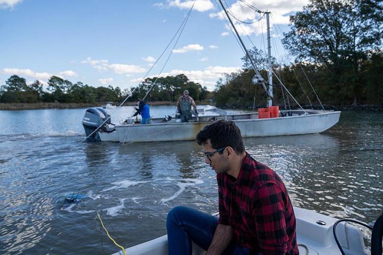
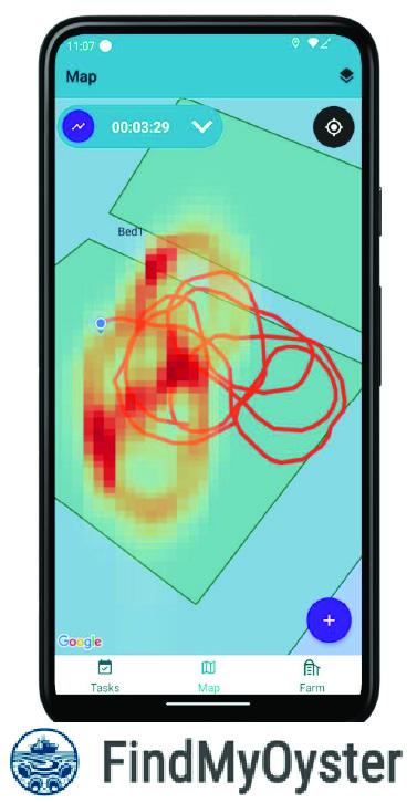
Fraunhofer USA has developed tools like the “Find My Oyster” app to help farmers track harvests and Figure 15. An ROV collects data during oyster farming operations. (Photo Credit: Logan Bilbrough, UMD Extension) optimize operations using S3AM data. Their work supports software development and data integration for oyster aquaculture. Visit https://findmyoyster.com/ to learn more.
University of Maryland Extension
The University of Maryland Extension (extension.umd.edu) supports oyster aquaculture in Maryland by offering hands-on education, training programs, and resources like workshops, demonstration farms, and individual consultations to help growers succeed. They also collaborate with partners to provide technical support, financing options, and habitat improvement programs that promote sustainable oyster farming and boost local economies.
- Maryland Aquaculture Extension [https://extension.umd.edu/programs/agriculture-food-systems/program-areas/animal-science/aquaculture/]
- Oyster Aquaculture Dashboard [https://go.umd.edu/OysterAquacultureDashboard]
- Maryland Sea Grant [https://www.mdsg.umd.edu/]
- Aquaculture Information Exchange [https://aquainfoexchange.org/]
Maryland Department of Natural Resources
The Maryland Department of Natural Resources (DNR) oversees and supports oyster aquaculture through permitting, lease management, and regulatory compliance. It provides tools like the Aquaculture Siting Tool to help farmers find suitable locations and requires monthly harvest reporting from leaseholders.
- Shellfish Aquaculture Resources [https://dnr.maryland.gov/fisheries/pages/aquaculture/shellfish.aspx]
- Aquaculture Permitting [https://dnr.maryland.gov/fisheries/pages/aquaculture/permitting.aspx]
- Aquaculture Permit Instructions [https://dnr.maryland.gov/fisheries/Documents/Shellfish-Lease-Application-Instructions.pdf]
- Aquaculture Siting Tool [https://experience.arcgis.com/ experience/65ecfd2a1fdd41578d858efbd16f9ec0]
References
Brooks, W. K. (1996). The oyster. Johns Hopkins University Press.
Flimlin, G., Macfarlane, S., Rhodes, E., & Rhodes, K. (2010). Best management practices for the East Coast shellfish aquaculture industry. East Coast Shellfish Growers Association. https://extension.umd.edu/sites/extension.umd.edu/files/2021-02/BMP_Manual.pdf
Goetz, A. (2023). Eyes on the prize catch: Can smart tech modernize oyster farming? Chesapeake Quarterly, 22(1). https://storymaps.arcgis.com/stories/01d793ce0dba439787f21f9ef7e92749
Maryland Department of Natural Resources. (2025). Maryland oyster population status reports (fall survey). https://dnr.maryland.gov/fisheries/pages/shellfish-monitoring/reports.aspx
Maryland OneStop. (2025). Joint application for commercial shellfish aquaculture lease and Corps of Engineers federal permit. https://onestop.md.gov/public_profiles/joint-application-for-commercial-shellfish-aquaculture-lease-and-corps-of-engineers-federal-permit-6185553da9691101cfedc597
U.S. Food and Drug Administration. (2023). National Shellfish Sanitation Program (NSSP) guide for the control of molluscan shellfish (2023 revision). https://www.fda.gov/media/181370/download?attachment
D. ALLEN PATTILLO
dapatt@umd.edu
MATT PARKER
mparke11@umd.edu
DON WEBSTER
dwebster@umd.edu
MIAO YU
mmyu@umd.edu
YANG TAO
ytao@umd.edu
NIKHIL CHOPRA
nchopra@umd.edu
YIANNIS ALOIMONOS
jyaloimo@umd.edu
GUDJON MAGNUSSON
This publication, New Technologies for Oyster Farming: An Overview of Smart, Sustainable Shellfish Aquaculture Management (S3AM) (EB-2025-0797), is a part of a collection produced by the University of Maryland Extension within the College of Agriculture and Natural Resources.
The information presented has met UME peer-review standards, including internal and external technical review. For help accessing this or any UME publication contact: itaccessibility@umd.edu
For more information on this and other topics, visit the University of Maryland Extension website at extension.umd.edu
University programs, activities, and facilities are available to all without regard to race, color, sex, gender identity or expression, sexual orientation, marital status, age, national origin, political affiliation, physical or mental disability, religion, protected veteran status, genetic information, personal appearance, or any other legally protected class.
When citing this publication, please use the suggested format:
Pattillo, D. A., Parker, M., Webster, D.,Yu, M., Tao, Y., Chopra, N., Aloimonos, Y., & Magnusson, G. (2026). New Technologies for Oyster Farming: An Overview of Smart, Sustainable Shellfish Aquaculture Management (S3AM) (EB-2025-0797). University of Maryland Extension. go.umd.edu/FS-2025-0797.